
CarbonWatch (Forestry and Carbon Credit Management Platform)By using high-resolution satellite imagery technology combined with artificial intelligence and machine learning to analyze and estimate carbon sequestration in the forestry sector, this method has been certified by the Thailand Greenhouse Gas Management Organization (TGO) for its high accuracy and reliability. It helps reduce time and costs in the field survey and can efficiently prepare part of the documents required for project registration (PDD)

CarbonWatch provides support to project developers in registering carbon credits. The platform offers services in two main stages: pre-registration and post-registration.

In the pre-registration phase, CarbonWatch assists project developers in classifying forest types and canopy density assessment before evaluating carbon sequestration.
In the post-registration phase, project developers are required to continuously monitor and inspect the project area for occurrences of forest fires or deforestation before applying for certification from the Thailand Greenhouse Gas Management Organization (TGO).
There are 3 services for pre-registration which are Forest Classification, Canopy Density Assessment ,and Base-line Assessment
1. Forest Type Classification
Forest classification is a critical step in developing carbon credit projects, utilizing satellite technology and field data to accurately identify the ecological characteristics of forests. Forests are classified based on characteristics, such as tropical rainforests, mixed deciduous forests, or deciduous dipterocarp forests, each with a different capacity for carbon sequestration. Additionally, land use classification enables more precise planning of survey areas, ensuring alignment with the actual landscape conditions.

2. Canopy Density Assessment
Satellite-based canopy density assessment enables efficient large-scale evaluation by classifying canopy density into high, medium, and low levels using AI. This information helps survey teams to select diverse vegetation plots that correspond to the actual landscape, enhancing data collection efficiency and forest health assessments. Additionally, it aids in analyzing each area’s carbon sequestration potential.

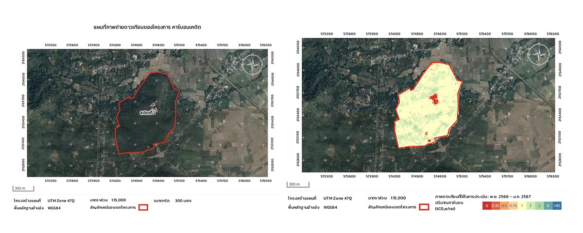
3. Base-line Assessment
After the project developers have completed the forest classification and canopy density assessment, they can proceed to evaluate the carbon sequestration potential of the forested area. This approach is convenient, fast, and cost-effective, as it reduces the survey plot area to only 1% of the project area. Furthermore, this model has been certified by the Thailand Greenhouse Gas Management Organization (TGO), supporting the preparation of project design document.
There are 2 services for Post-registration which are Wildfire and Deforest monitoring
1. Wildfire Monitoring
Wildfire Monitoring is a highly efficient system for tracking and reducing wildfire risks. It can quickly detect hotspots, enabling timely alerts to operational teams and relevant agencies through various channels, including LINE Official Account, which allows staff to access crucial information easily and swiftly. Additionally, burn scar analysis helps in assessing monthly wildfire damage by identifying burned area. This data is invaluable for planning forest restoration and for obtaining carbon credit certification from the Thailand Greenhouse Gas Management Organization (TGO).

2. Deforest Monitoring
We are developing a model that uses satellite data and AI to monitor yearly forest changes, including loss and regeneration. This precise data supports effective conservation planning and assesses impacts from external factors like wildfires, encroachment, and deforestation, enabling timely interventions and prioritizing critical areas for preservation.


.png)

